
Fil:Ohio Country en.png
Storlek på förhandsvisningen: 793 × 599 pixlar. Andra upplösningar: 318 × 240 pixlar | 635 × 480 pixlar | 1 016 × 768 pixlar | 1 217 × 920 pixlar.
Originalfil (1 217 × 920 pixlar, filstorlek: 1,41 Mbyte, MIME-typ: image/png)
| Denna fil tillhandahålls av Wikimedia Commons. Informationen nedan är kopierad från dess filbeskrivningssida. |
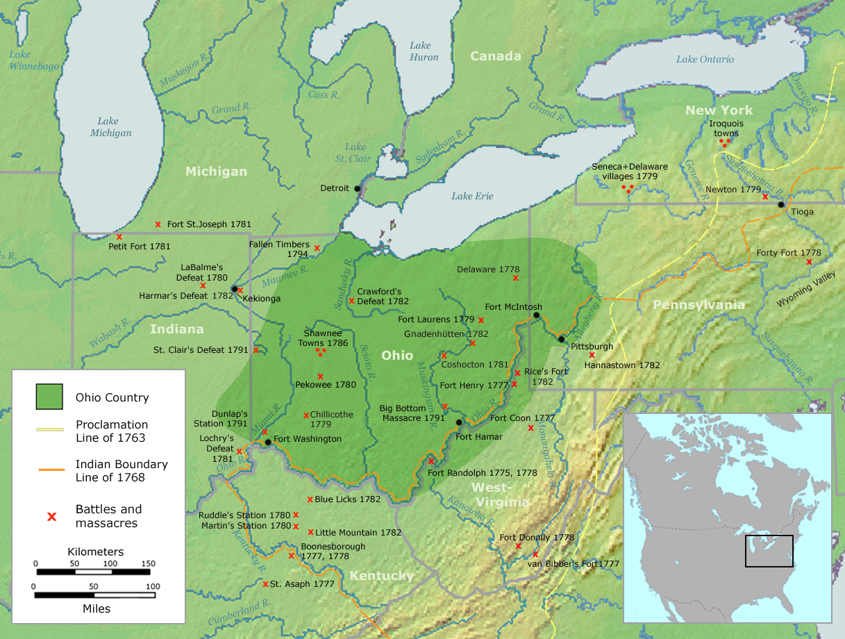
| Beskrivning | Map of the Ohio Country (English version) | ||||
| Datum | |||||
| Källa | Own work by Nikater, submitted to the public domain. Background map courtesy of Demis, www.demis.nl and Wilcomb E. Washburn (Hrsg.) Handbook of North American Indians. Vol. 4: History of Indian-White Relations. Smithsonian Institution Press, Washington D.C. 1988. ISBN 0-16004-583-5 | ||||
| Skapare | User:Nikater | ||||
| Tillstånd (Återanvändning av denna fil) |
|
||||
| Andra versioner | Deutsch |
Filhistorik
Klicka på ett datum/klockslag för att se filen som den såg ut då.
| Datum/Tid | Miniatyrbild | Dimensioner | Användare | Kommentar | |
|---|---|---|---|---|---|
| nuvarande | 21 september 2007 kl. 08.20 | | 1 217 × 920 (1,41 Mbyte) | Nikater | {{Information |Description=Map of the Ohio Country (English version) |Source=Own work by Nikater, submitted to the public domain. Background map courtesy of Demis, www.demis.nl and Wilcomb E. Washburn (Hrsg.) ''Handbook of North American Indians.'' Vol. 4 |
| 20 september 2007 kl. 13.50 |  | 1 217 × 920 (1,41 Mbyte) | Nikater | {{Information |Description=Map of the Ohio Country (English version) |Source=Own work by Nikater, submitted to the public domain. Background map courtesy of Demis, www.demis.nl and Wilcomb E. Washburn (Hrsg.) ''Handbook of North American Indians.'' Vol. 4 | |
| 17 september 2007 kl. 22.21 |  | 1 217 × 920 (1,41 Mbyte) | Nikater | {{Information |Description=Map of the Ohio Country (English version) |Source=Own work by Nikater, submitted to the public domain. Background map courtesy of Demis, www.demis.nl and Wilcomb E. Washburn (Hrsg.) ''Handbook of North American Indians.'' Vol. 4 | |
| 17 september 2007 kl. 22.05 |  | 1 217 × 920 (1,41 Mbyte) | Nikater | {{Information |Description=Map of the Ohio Country (English version) |Source=Own work by Nikater, submitted to the public domain. Background map courtesy of Demis, www.demis.nl and Wilcomb E. Washburn (Hrsg.) ''Handbook of North American Indians.'' Vol. 4 |
Filanvändning
Följande 2 sidor använder den här filen:
Global filanvändning
Följande andra wikier använder denna fil:
- Användande på ar.wikipedia.org
- Användande på arz.wikipedia.org
- Användande på ast.wikipedia.org
- Användande på bn.wikipedia.org
- Användande på ca.wikipedia.org
- Användande på cs.wikipedia.org
- Användande på en.wikipedia.org
- Användande på es.wikipedia.org
- Användande på fr.wikipedia.org
- Användande på gl.wikipedia.org
- Användande på id.wikipedia.org
- Användande på ja.wikipedia.org
- Användande på ko.wikipedia.org
- Användande på ms.wikipedia.org
- Användande på no.wikipedia.org
- Användande på pl.wikipedia.org
- Användande på ro.wikipedia.org
- Användande på ru.wikipedia.org
- Användande på so.wikipedia.org
- Användande på sq.wikipedia.org
- Användande på tr.wikipedia.org
- Användande på www.wikidata.org