
Fil:Pinus cembroides range map.png

Storlek på förhandsvisningen: 750 × 600 pixlar. Andra upplösningar: 300 × 240 pixlar | 600 × 480 pixlar | 1 000 × 800 pixlar.
Originalfil (1 000 × 800 pixlar, filstorlek: 28 kbyte, MIME-typ: image/png)
| Denna fil tillhandahålls av Wikimedia Commons. Informationen nedan är kopierad från dess filbeskrivningssida. |
Sammanfattning
| Beskrivning |
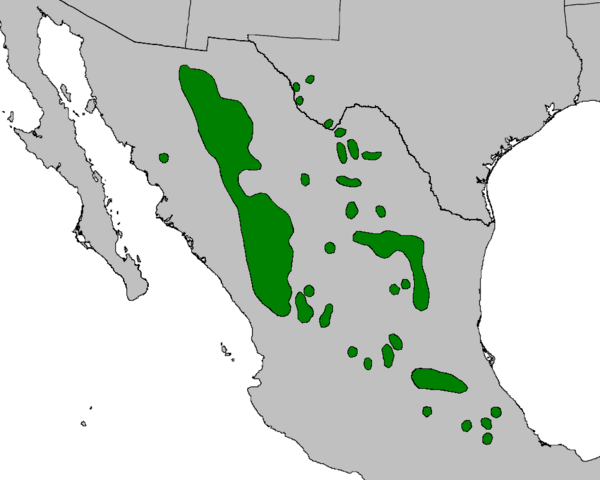
English: Range map of Pinus cembroides. |
| Datum | |
| Källa | Adapted from Digital representation of "Atlas of United States Trees" by Elbert L. Little, Jr. [1], with taxonomic update to remove Pinus remota and Pinus johannis |
| Skapare | U.S. Geological Survey |
| Andra versioner | File:Pinus cembroides range map.jpg (jpeg version) |
Licensiering
This image is in the public domain in the United States because it only contains materials that originally came from the United States Geological Survey, an agency of the United States Department of the Interior. For more information, see the official USGS copyright policy.
|
Filhistorik
Klicka på ett datum/klockslag för att se filen som den såg ut då.
| Datum/Tid | Miniatyrbild | Dimensioner | Användare | Kommentar | |
|---|---|---|---|---|---|
| nuvarande | 11 oktober 2023 kl. 01.44 | | 1 000 × 800 (28 kbyte) | MPF | update to remove species split Pinus lagunae (Baja Cal Sur); crop to fit better |
| 23 september 2013 kl. 12.53 |  | 1 003 × 1 160 (22 kbyte) | MPF | {{Information |Description={{en|Range map of ''Pinus cembroides''.}} |Source=Adapted from ''Digital representation of "Atlas of United States Trees"'' by Elbert L. Little, Jr. [http://esp.cr.usgs.gov/data/atlas/little/], with taxonomic update to remove... |
Filanvändning
Följande sida använder den här filen:
Global filanvändning
Följande andra wikier använder denna fil:
- Användande på ceb.wikipedia.org
- Användande på cs.wikipedia.org
- Användande på de.wikipedia.org
- Användande på en.wikipedia.org
- Användande på es.wikipedia.org
- Användande på fi.wikipedia.org
- Användande på fr.wikipedia.org
- Användande på is.wikipedia.org
- Användande på lt.wikipedia.org
- Användande på pl.wikipedia.org
- Användande på pt.wikipedia.org
- Användande på species.wikimedia.org
- Användande på uk.wikipedia.org
- Användande på www.wikidata.org