
Fil:River Nith estuary.jpg

Storlek på förhandsvisningen: 800 × 533 pixlar. Andra upplösningar: 320 × 213 pixlar | 640 × 427 pixlar | 1 024 × 683 pixlar | 1 280 × 853 pixlar | 2 560 × 1 707 pixlar | 3 504 × 2 336 pixlar.
Originalfil (3 504 × 2 336 pixlar, filstorlek: 8,68 Mbyte, MIME-typ: image/jpeg)
| Denna fil tillhandahålls av Wikimedia Commons. Informationen nedan är kopierad från dess filbeskrivningssida. |
Sammanfattning
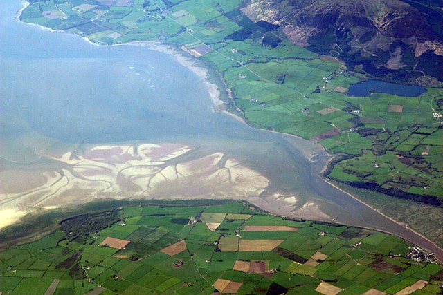
| Beskrivning | The estuary of the River Nith, Scotland, at low tide; opening into Solway Firth. This is a view of the Nith estuary from the north-east. The group of buildings at bottom right is the village of Glencaple. At bottom left near the wooded area is Caerlaverock Castle. At top right is Loch Kindar and the hill above is called Criffel. Just beyond the top left of photo is the birthplace of John Paul Jones. |
| Datum | |
| Källa | https://www.flickr.com/photos/52614599@N00/483602946 |
| Skapare | Doc Searls from Santa Barbara, USA |
Licensiering
Denna fil har gjorts tillgänglig under licensen Creative Commons Erkännande-Dela Lika 2.0 Generisk
- Du är fri:
- att dela – att kopiera, distribuera och sända verket
- att remixa – att skapa bearbetningar
- På följande villkor:
- erkännande – Du måste ge lämpligt erkännande, ange en länk till licensen och indikera om ändringar har gjorts. Du får göra det på ett lämpligt sätt, men inte på ett sätt som antyder att licensgivaren stödjer dig eller din användning.
- dela lika – Om du remixar, transformerar eller bygger vidare på materialet måste du distribuera dina bidrag under samma eller en kompatibel licens som originalet.
| Denna bild laddades ursprungligen upp på Flickr av dsearls på https://www.flickr.com/photos/52614599@N00/483602946. 5 maj 2007 granskades den av roboten FlickreviewR och befanns vara licensierad under licensen cc-by-sa-2.0. |
This is a view of the Nith estuary from the north-east. The group of buildings at bottom right is the village of Glencaple. At bottom left near the wooded area is Caerlaverock Castle. At top right is Loch Kindar and the hill above is called Criffel. Just beyond the top left of photo is the birthplace of John Paul Jones.
Filhistorik
Klicka på ett datum/klockslag för att se filen som den såg ut då.
| Datum/Tid | Miniatyrbild | Dimensioner | Användare | Kommentar | |
|---|---|---|---|---|---|
| nuvarande | 5 maj 2007 kl. 09.14 | | 3 504 × 2 336 (8,68 Mbyte) | Sandstein | {{Information |Description= The estuary of the River Nith, Scotland, at low tide; opening into Solway Firth. On the near shore, Bowness-on-Solway. On the far, Annan, in Dumfries and Galloway. |Source= http://www.flickr.com/photos/52614599@N00/483602946 |D |
Filanvändning
Följande sida använder den här filen:
Global filanvändning
Följande andra wikier använder denna fil:
- Användande på ar.wikipedia.org
- Användande på arz.wikipedia.org
- Användande på ast.wikipedia.org
- Användande på bn.wikipedia.org
- Användande på br.wikipedia.org
- Användande på ceb.wikipedia.org
- Användande på cs.wikipedia.org
- Användande på cy.wikipedia.org
- Användande på dag.wikipedia.org
- Användande på de.wikipedia.org
- Användande på en.wikipedia.org
- Användande på en.wikivoyage.org
- Användande på eo.wikipedia.org
- Användande på es.wikipedia.org
- Användande på eu.wikipedia.org
- Användande på fa.wikipedia.org
- Användande på fr.wikipedia.org
- Användande på fy.wikipedia.org
- Användande på ga.wikipedia.org
- Användande på gd.wikipedia.org
- Användande på gv.wikipedia.org
- Användande på hak.wikipedia.org
- Användande på id.wikipedia.org
- Användande på incubator.wikimedia.org
- Användande på it.wikipedia.org
- Användande på it.wikibooks.org
- Användande på it.wikiversity.org
- Användande på ja.wikipedia.org
- Användande på kbd.wikipedia.org
- Användande på lt.wikipedia.org
- Användande på nl.wikipedia.org
Visa mer globalt användande av denna fil.