
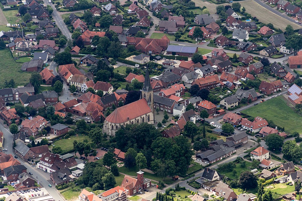
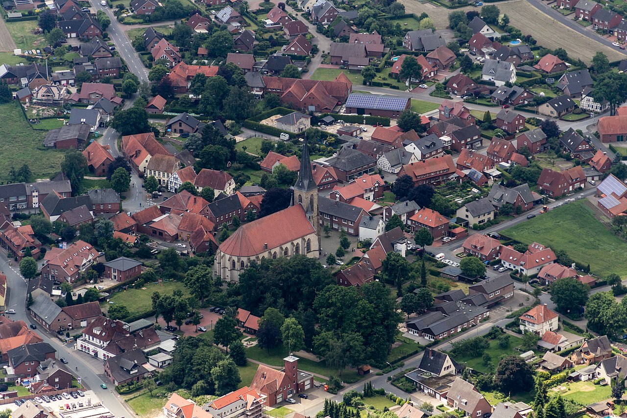
Fil:Sassenberg, Füchtorf, St.-Mariä-Himmelfahrt-Kirche -- 2014 -- 8570.jpg

Storlek på förhandsvisningen: 800 × 533 pixlar. Andra upplösningar: 320 × 213 pixlar | 640 × 427 pixlar | 1 024 × 683 pixlar | 1 280 × 853 pixlar | 2 560 × 1 707 pixlar | 4 869 × 3 246 pixlar.
Originalfil (4 869 × 3 246 pixlar, filstorlek: 11,63 Mbyte, MIME-typ: image/jpeg)
| Denna fil tillhandahålls av Wikimedia Commons. Informationen nedan är kopierad från dess filbeskrivningssida. |
Sammanfattning
| Beskrivning |
|
||||||||||||||||||||||||||||
| Plats | |||||||||||||||||||||||||||||
| Motiv | St. Mariä Himmelfahrt – church building in Sassenberg, Germany | ||||||||||||||||||||||||||||
| Technical Specifications |
|
||||||||||||||||||||||||||||
| Bilddata |
|
||||||||||||||||||||||||||||
| Datum | Bild tagen: 1 juni 2014, 12:45 | ||||||||||||||||||||||||||||
| Källa | Eget arbete | ||||||||||||||||||||||||||||
| Skapare |
|
||||||||||||||||||||||||||||
| Tillstånd (Återanvändning av denna fil) |
 .svg) I. Licence
This photograph is protected by copyright law. However, it may be used for free by anyone, provided it is used in accordance with the license Creative Commons License “Attribution-ShareAlike 4.0 International” (CC BY-SA 4.0). These include, among other things, the naming of the author and the license, as well as the setting of a link to the license text or its complete imprint. The attribution should be done as follows:
Please read the text of the license carefully before using the photograph. If you do not agree with the conditions of the license or if you do not understand these conditions, please refrain from using the photo. If you have any questions regarding the license or the reuse of the image, please contact me before using it. If you do not comply with the terms of the license, you do not acquire any right to use the image. If you need another license to use, please contact the author before using.
For informations about the licence see section Licensiering or as human-readable summary or as full licence text at Creative Commons. In addition to the above, a link to the source - so this page with the descriptions and license terms - is appreciated. More information or examples of use can be found at re-use (with example file). The Attribution Generator is helpful in licensing matters.
As an alternative to the Creative Commons License CC BY-SA 4.0, the Free Art License (from version 1.3) may also be used.
II. Fairness
From printed materials and other tangible products that use that work, the user is asked to send a copy to the author as thank you. However, this is not a condition for the use of the photo, but a voluntary service. The mailing address can be requested via the contact options.
Please note that the author had quite considerable effort to draw up this file. Thus, it is only fair to comply with the conditions of free licenses listed here. In the case of violation of the license conditions, the rights granted hereunder will expire automatically.
III. Disclaimer
Please note that the license applies solely for the reuse of the photograph itself. The license doesn't grant you any right regarding the depicted object (eg, copyright or proprietary rights) or the personality rights of the person eventually shown. (See licences and non-copyright restrictions.) I do not grant any warranty that the subsequent use of the photograph is legally possible concerning the object or person shown in the photograph. You are responsible to check and respect these rights in the publication in the respective medium or country.
The author is not responsible for the accuracy of the information contained herein (description, title, etc.). Likewise, the author assumes no liability for further use. Please note the general disclaimer and please read reusing content outside Wikimedia too.
IV. Contact
|
||||||||||||||||||||||||||||
| Andra versioner | |||||||||||||||||||||||||||||
| Erkännande (krävs av licensen) | Dietmar Rabich / Wikimedia Commons / /
|
||||||||||||||||||||||||||||
| Keywords | Aerial view, Architecture, Architektur, Bauwerk, Christentum, Denkmal, Deutschland, Frühling, Germany, Gotteshaus, Kirche, Kreis Warendorf, Kultur, Luftaufnahme, Luftbild, Münsterland, Nordrhein-Westfalen, North Rhine-Westphalia, Religion, Religiöses Gebäude, Sakralbau, Sassenberg, Westfalen, 2014 | ||||||||||||||||||||||||||||


| Objektposition | | Se denna och andra närliggande bilder på: OpenStreetMap |
|---|
| Kameraposition | | Se denna och andra närliggande bilder på: OpenStreetMap |
|---|
|
Plats |
The geocoded location of the location of this image is only correct to the nearest 3 km for privacy or other reasons. Please do not improve the accuracy of the coordinates even if you are able to do so. |
|---|
| Dieses Foto entstand aufgrund eines Projektes, das von Wikimedia Deutschland e. V. gefördert wurde.
Im Rahmen des „Community-Projektbudgets“ sollen Luftbilder u. a. vom Münsterland angefertigt werden. Das Projekt „Fotoflüge“ wurde im September 2011 begonnen. Ziel dieses Fotoflugs war das östliche Münsterland. Flüge des Projekts im Münsterland: 12. April 2014 · 1. Juni 2014 · 7. Juni 2014 · 20. Juli 2014 · 1. November 2014 |
Licensiering
Dietmar Rabich, upphovsrättsinnehavaren av detta verk, publicerar härmed det under följande licens:
Denna fil har gjorts tillgänglig under licensen Creative Commons Erkännande-DelaLika 4.0 Internationell.
Erkännande: Dietmar Rabich
- Du är fri:
- att dela – att kopiera, distribuera och sända verket
- att remixa – att skapa bearbetningar
- På följande villkor:
- erkännande – Du måste ge lämpligt erkännande, ange en länk till licensen och indikera om ändringar har gjorts. Du får göra det på ett lämpligt sätt, men inte på ett sätt som antyder att licensgivaren stödjer dig eller din användning.
- dela lika – Om du remixar, transformerar eller bygger vidare på materialet måste du distribuera dina bidrag under samma eller en kompatibel licens som originalet.
Notes
Photographs
|
You like this photograph? That pleases me very much! You would like to see more of my pictures? With pleasure.
Wikimedia Commons has a large number of my photographs available under a free license. This makes it easy for you and me. The license details are for each picture. The use is easier than you think, because in essence, this is just the attribution in the form I want. In addition, usage notes are listed for each picture. And if it does not fit, just ask. My contact information is also available with every photograph. |


Filhistorik
Klicka på ett datum/klockslag för att se filen som den såg ut då.
| Datum/Tid | Miniatyrbild | Dimensioner | Användare | Kommentar | |
|---|---|---|---|---|---|
| nuvarande | 12 oktober 2014 kl. 10.44 | | 4 869 × 3 246 (11,63 Mbyte) | XRay | VicuñaUploader 1.20 |
Filanvändning
Följande sida använder den här filen:
Global filanvändning
Följande andra wikier använder denna fil:
- Användande på en.wikipedia.org
- Användande på nn.wikipedia.org