
Fil:Tikal map.JPG
Storlek på förhandsvisningen: 566 × 600 pixlar. Andra upplösningar: 226 × 240 pixlar | 453 × 480 pixlar | 724 × 768 pixlar | 966 × 1 024 pixlar | 1 600 × 1 696 pixlar.
Originalfil (1 600 × 1 696 pixlar, filstorlek: 263 kbyte, MIME-typ: image/jpeg)
| Denna fil tillhandahålls av Wikimedia Commons. Informationen nedan är kopierad från dess filbeskrivningssida. |
Sammanfattning

|
En vektorversion av denna bild (SVG) finns tillgänglig.
Den skall användas istället för denna rasterbild, när det är fördelaktigt. File:Tikal map.JPG → File:Tikal map vector.svg
För mer information om vektorgrafik, se artikeln Commons transition to SVG (engelska). Det finns också information om MediaWikis stöd för SVG-bilder (engelska). |
 |
| Beskrivning |
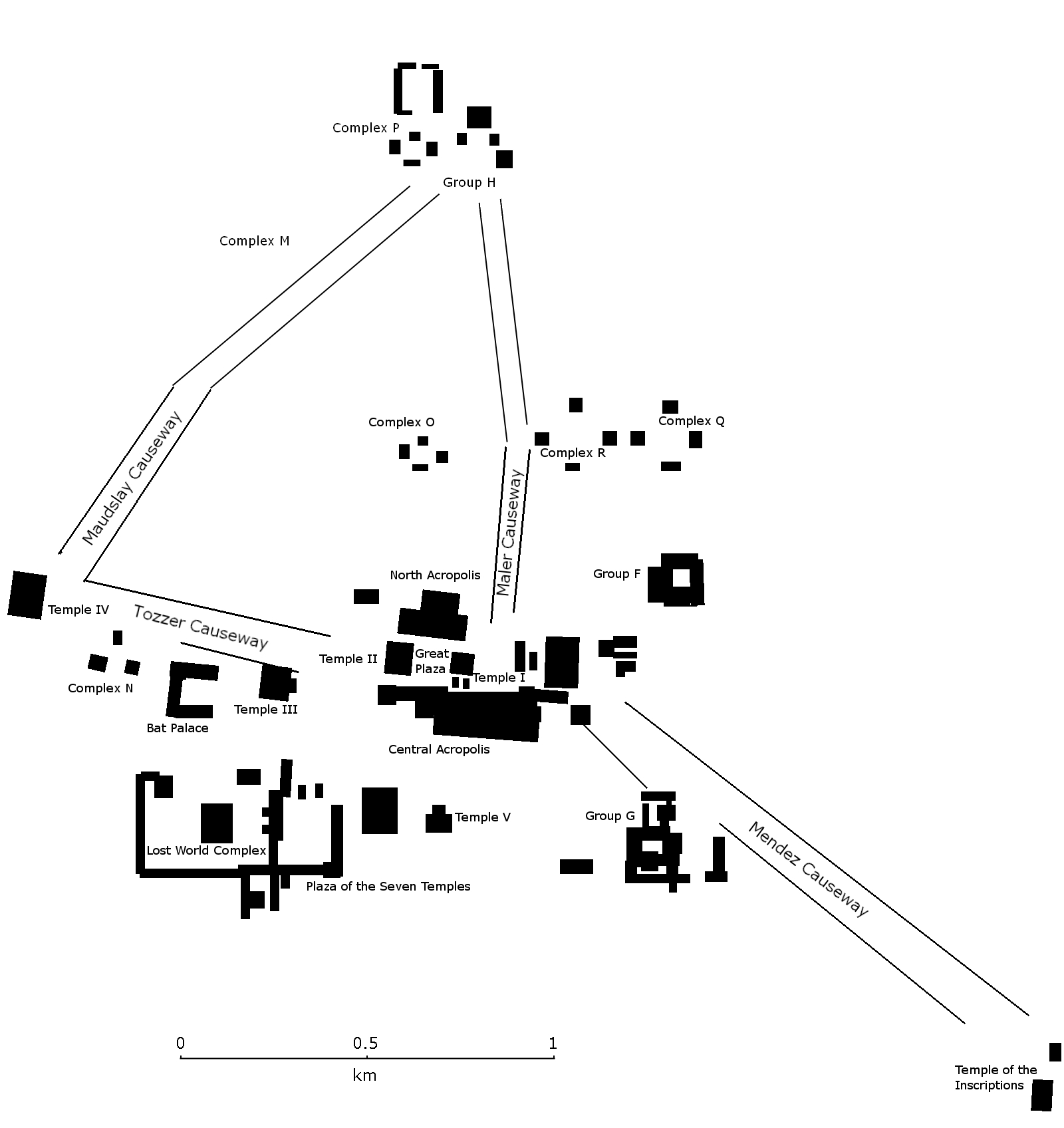
English: Map of the site core of Tikal, showing the major structures of the Mayan site.
Español: Mapa del nucleo de Tikal con las estructuras más importantes. Petén, Guatemala. |
| Datum | |
| Källa | Eget arbete |
| Skapare | Simon Burchell |
Licensiering
Jag, upphovsrättsinnehavaren av detta verk, publicerar härmed det under följande licens:
Denna fil har gjorts tillgänglig under licensen Creative Commons Erkännande-Dela Lika 3.0 Generisk
- Du är fri:
- att dela – att kopiera, distribuera och sända verket
- att remixa – att skapa bearbetningar
- På följande villkor:
- erkännande – Du måste ge lämpligt erkännande, ange en länk till licensen och indikera om ändringar har gjorts. Du får göra det på ett lämpligt sätt, men inte på ett sätt som antyder att licensgivaren stödjer dig eller din användning.
- dela lika – Om du remixar, transformerar eller bygger vidare på materialet måste du distribuera dina bidrag under samma eller en kompatibel licens som originalet.

|
Tillstånd ges att kopiera, distribuera och/eller modifiera detta dokument under villkoren i GNU Free Documentation License, Version 1.2 eller senare version publicerad av Free Software Foundation, utan oföränderliga avsnitt, framsidestexter eller baksidestexter. En kopia av licensen ingår i avsnittet GNU Free Documentation License. |
Filhistorik
Klicka på ett datum/klockslag för att se filen som den såg ut då.
| Datum/Tid | Miniatyrbild | Dimensioner | Användare | Kommentar | |
|---|---|---|---|---|---|
| nuvarande | 15 november 2009 kl. 00.33 | | 1 600 × 1 696 (263 kbyte) | Simon Burchell | Include northern portion of site core |
| 14 november 2009 kl. 17.28 |  | 1 600 × 1 103 (212 kbyte) | Simon Burchell | {{Information |Description={{en|1=Map of the site core of Tikal, showing the major structures. Petén, Guatemala.}} {{es|1=Mapa del nucleo de Tikal con las estructuras más importantes. Petén, Guatemala.}} |Source={{own}} |Author=[[User:Simon Burchell|Si |
Filanvändning
Inga sidor använder den här filen.
Global filanvändning
Följande andra wikier använder denna fil:
- Användande på en.wikipedia.org
- Användande på pl.wikipedia.org