
Fil:Tribal Kingdom of Samo-sl version.PNG

Storlek på förhandsvisningen: 601 × 600 pixlar. Andra upplösningar: 241 × 240 pixlar | 481 × 480 pixlar | 852 × 850 pixlar.
Originalfil (852 × 850 pixlar, filstorlek: 149 kbyte, MIME-typ: image/png)
| Denna fil tillhandahålls av Wikimedia Commons. Informationen nedan är kopierad från dess filbeskrivningssida. |
| Beskrivning |
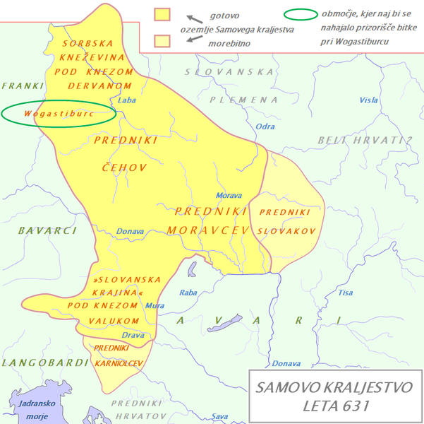
English: Tribal Kingdom of Samo. Map is based on the maps in: Korošec, Paola (1990): Alpski Slovani- Die Alpenslawen, Ljubljana, Znanstveni institut Filozofske fakultete, unnamed map on the page 18; Šavli, Jožko (1995): Sovenija: Podoba evropskega naroda, Bilje, založba Humar, map Samovo kraljestvo on the page 19; Barford, Paul M. (2001): The Early Slavs, Cornell University Press, map on the page 356, named Geography of the Slav settlement of Polabia- concerning the location of Sorbs east of Saale; map IV on page 397 for Sorbian culture, Devinska-Nova ves culture and Avarian state. It is also based on descriptions in: Štih, Peter (2001): Ozemlje Slovenije v zgodnjem srednjem veku: osnovne poteze zgodovinskega razvoja od začetka 6. do konca 9. stoletja, Ljubljana, Filozofska fakulteta; page 30- concerning the relationsship between king Samo and the ancestros of Slovenians; Korošec, Paola (1990): Alpski Slovani- Die Alpenslawen, Ljubljana, Znanstveni institut Filozofske fakultete, page 17 – concerning the Sorbs and their duke Dervan. For eastern and southern extant of tribal kingdom: known territories are shown by the scheme of franco-slavic border and information about the conflicts with Avars is imlemented. The inclusion of Bohemian basin is followed. Contacts with Avars are reached through the territory of Moravians anf Eastern Alps. The territories further east and south, which are in proximity of Avars, could be parts of tribal kingdom, too. |
| Datum | (UTC) |
| Källa | |
| Skapare |
|
| Detta är en retuscherad eller på annat sätt behandlad bild, med vilket menas att den har redigerats digitalt från sitt original. Redigeringar: The map of Danube basin was used to create map of Kingdom of Samo. Originalet kan ses här: Waterways of SE Central Europe.svg. Redigeringar gjorda av Bostjan46.
|
Jag, upphovsrättsinnehavaren av detta verk, publicerar härmed det under följande licens:
| Jag, upphovsrättsinnehavaren till detta verk, släpper detta verk i public domain. Detta gäller globalt. I vissa länder kan detta inte vara juridiskt möjligt; i så fall: Jag ger härmed envar rätten att använda detta verk för alla ändamål, utan några villkor, förutom villkor som lagen ställer. |
Ursprunglig uppladdningslogg
This image is a derivative work of the following images:
- File:Waterways_of_SE_Central_Europe.svg licensed with PD-self
- 2010-01-08T20:49:27Z Kmiki87 1415x1059 (292577 Bytes) {{Information |Description={{en|1=Waterways along the central and lower Danube, including the Bohemian and Carpathian Basins, the northern Balkans, parts of Austria, southern Poland and Western Ukraine.}} |Source={{own}} |Aut
Uploaded with derivativeFX
Filhistorik
Klicka på ett datum/klockslag för att se filen som den såg ut då.
| Datum/Tid | Miniatyrbild | Dimensioner | Användare | Kommentar | |
|---|---|---|---|---|---|
| nuvarande | 9 januari 2011 kl. 20.21 | | 852 × 850 (149 kbyte) | Bostjan46 | The text for Dalmatian Slavs was changed (Slavic tribes under avarian rule>>Ancestors of Croats). |
| 9 januari 2011 kl. 19.13 |  | 852 × 850 (150 kbyte) | Bostjan46 | {{Information |Description={{en|1=Tribal Kingdom of Samo. Map is based on the maps in: Korošec, Paola (1990): ''Alpski Slovani- Die Alpenslawen'', Ljubljana, Znanstveni institut Filozofske fakultete, unnamed map on the page 18; Šavli, Jožko (1995): '' |
Filanvändning
Följande sida använder den här filen:
Global filanvändning
Följande andra wikier använder denna fil:
- Användande på az.wikipedia.org
- Användande på be.wikipedia.org
- Användande på bg.wikipedia.org
- Användande på de.wikipedia.org
- Användande på gl.wikipedia.org
- Användande på lt.wikipedia.org
- Användande på pl.wikipedia.org
- Användande på ru.wikipedia.org
- Användande på sl.wikipedia.org
- Användande på sr.wikipedia.org
- Användande på szl.wikipedia.org