
Fil:Zaire 96map.png

Det finns ingen version med högre upplösning.
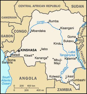
Zaire_96map.png (350 × 376 pixlar, filstorlek: 30 kbyte, MIME-typ: image/png)
| Denna fil tillhandahålls av Wikimedia Commons. Informationen nedan är kopierad från dess filbeskrivningssida. |
Sammanfattning
A map of Zaire from the 1996 World Factbook (as mirrored here). The GIF has been converted to a PNG. The map is also at the PCL map collection here.
Licensiering
This image is in the public domain because it contains materials that originally came from the United States Central Intelligence Agency's World Factbook.
|
 |
Filhistorik
Klicka på ett datum/klockslag för att se filen som den såg ut då.
| Datum/Tid | Miniatyrbild | Dimensioner | Användare | Kommentar | |
|---|---|---|---|---|---|
| nuvarande | 27 december 2006 kl. 11.01 | | 350 × 376 (30 kbyte) | Hoshie | A map of Zaire from the 1996 World Factbook (as mirrored [http://dlhoffman.com/publiclibrary/factbook96/factbook/map-gif/cg-150.gif here]). The GIF has been converted to a PNG. The map is also at the PCL map collection [http://www.lib.utexas.edu/maps/cia9 |
Filanvändning
Inga sidor använder den här filen.
Global filanvändning
Följande andra wikier använder denna fil:
- Användande på azb.wikipedia.org
- Användande på en.wikipedia.org
- Användande på ja.wikipedia.org
- Användande på no.wikipedia.org
- Användande på pl.wikipedia.org
- Användande på ru.wikipedia.org