Soke of Peterborough
Utseende
| Soke of Peterborough | ||
|
||
| Land | ||
|---|---|---|
| Riksdel | England | |
| Grevskap | Cambridgeshire Northamptonshire | |
| Koordinater | 52°34′17″N 0°14′32″V / 52.5714°N 0.2421°V | |
| Peterborough | ||
| Grundad | 1889 | |
| Tidszon | UTC (UTC+0) | |
| - sommartid | BST (UTC+1) | |
| Geonames | 2637553 | |
|
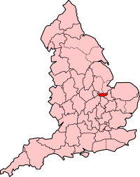
Läge i Storbritannien
| ||
Soke of Peterborough var ett grevskap 1889–1965 när det uppgick i Huntingdon and Peterborough och Northamptonshire, i England. Grevskap hade 74 758 invånare år 1961.[1] Peterborough var det administrativa centrumet.
Distrikt
[redigera | redigera wikitext]Referenser
[redigera | redigera wikitext]- ^ ”Population statistics the Soke of Peterborough AdmC through time”. A Vision of Britain through Time. https://visionofbritain.org.uk/unit/10152914/cube/TOT_POP. Läst 31 januari 2024.
- ^ ”Relationships and changes the Soke of Peterborough AdmC through time”. A Vision of Britain through Time. https://visionofbritain.org.uk/unit/10152914. Läst 31 januari 2024.
Externa länkar
[redigera | redigera wikitext] Wikimedia Commons har media som rör Soke of Peterborough.


