
Fil:Flooding along the Rio Negro, Uruguay.jpg

Storlek på förhandsvisningen: 800 × 533 pixlar. Andra upplösningar: 320 × 213 pixlar | 640 × 427 pixlar | 1 024 × 683 pixlar | 1 280 × 853 pixlar | 2 049 × 1 366 pixlar.
Originalfil (2 049 × 1 366 pixlar, filstorlek: 1,61 Mbyte, MIME-typ: image/jpeg)
| Denna fil tillhandahålls av Wikimedia Commons. Informationen nedan är kopierad från dess filbeskrivningssida. |
Sammanfattning
| Beskrivning |
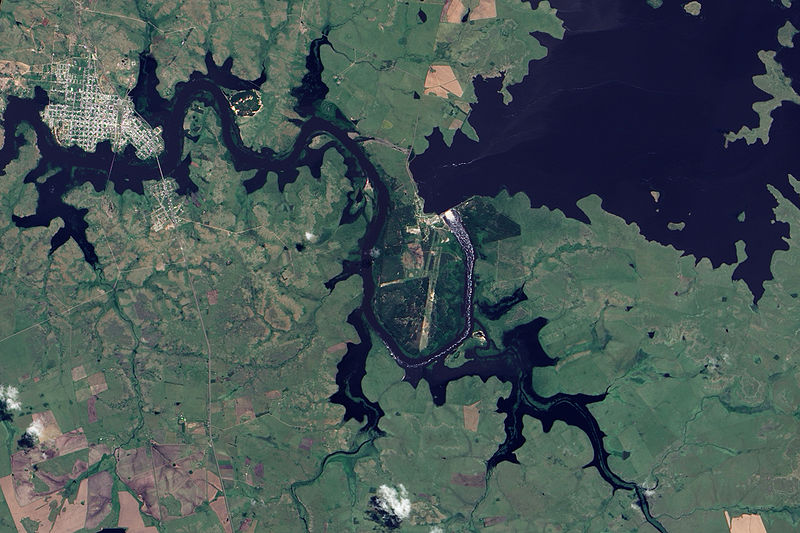
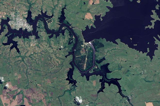
English: This true-colour image shows Rio Negro flowing past Paso de Los Toros. Throughout the scene, the river has overflowed its banks, which are still visible in places as narrow strips of plant-covered land. Flood-waters submerge not only parts of the land east of town, but also several parts of the city itself. One tributary immediately east of the city has expanded to the same width as the Rio Negro. The south-eastern quadrant of the city has been whittled away by flood-waters to form a fairly thin strip of land poking into the river. The normally straight southern edge of Paso de Los Toros looks as if the river has bitten into it with massive teeth. |
| Datum | |
| Källa | NASA Earth Observatory |
| Skapare | Jesse Allen |
Image captured by the Advanced Land Imager (ALI) on NASA’s Earth Observing-1 (EO-1) satellite. Image created using EO-1 ALI data provided courtesy of the NASA EO-1 team. Instrument: EO-1 - ALI
Licensiering
| Denna fil är allmän egendom eftersom den skapades av NASA. NASA:s upphovsrättspolicy hävdar att "material från NASA inte är upphovsrättsskyddad om inte annat anges". (Se Template:PD-USGov, NASA:s upphovsrättspolicy eller JPL-bildanvändningspolicy.) | ||
 |
Varningar:
|
| Annotations | This image is annotated: View the annotations at Commons |
Filhistorik
Klicka på ett datum/klockslag för att se filen som den såg ut då.
| Datum/Tid | Miniatyrbild | Dimensioner | Användare | Kommentar | |
|---|---|---|---|---|---|
| nuvarande | 9 december 2009 kl. 12.33 | | 2 049 × 1 366 (1,61 Mbyte) | Originalwana | {{Information |Description={{en|1=This true-colour image shows Rio Negro flowing past Paso de Los Toros. Throughout the scene, the river has overflowed its banks, which are still visible in places as narrow strips of plant-covered land. Flood-waters subme |
Filanvändning
Följande sida använder den här filen:
Global filanvändning
Följande andra wikier använder denna fil:
- Användande på en.wikipedia.org
- Användande på he.wikipedia.org
- Användande på hr.wikipedia.org
- Användande på mk.wikipedia.org
- Användande på simple.wikipedia.org
- Användande på uk.wikipedia.org
- Användande på vec.wikipedia.org
- Användande på zh.wikipedia.org