
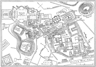
Fil:Map of downtown Rome during the Roman Empire large.png

Storlek på förhandsvisningen: 800 × 566 pixlar. Andra upplösningar: 320 × 226 pixlar | 640 × 452 pixlar | 1 024 × 724 pixlar | 1 099 × 777 pixlar.
Originalfil (1 099 × 777 pixlar, filstorlek: 74 kbyte, MIME-typ: image/png)
| Denna fil tillhandahålls av Wikimedia Commons. Informationen nedan är kopierad från dess filbeskrivningssida. |
| Detta är en retuscherad eller på annat sätt behandlad bild, med vilket menas att den har redigerats digitalt från sitt original. Redigeringar: rasterized. Originalet kan ses här: Map of downtown Rome during the Roman Empire large.jpg. Redigeringar gjorda av Helix84.
|
Sammanfattning
| Beskrivning |
Deutsch: Karte der antiken Innenstadt von Rom |
| Datum | |
| Källa | from the Nordisk familjebok (1916), band 23, artikeln "Rom" [1], upload to Swedish wikipedia 23.10.2003 by Den fjättrade ankan |
| Skapare | Okänd |
| Andra versioner | Derivative works of this file: Forum Romanum Arcus Augusti.jpg |
Licensiering
Denna bild publicerades första gången i den första (1876–1899), andra (1904–1926) eller tredje (1923–1937) upplagan av Nordisk familjebok. Upphovsrätten för det verket har gått ut, och bilderna är fria att använda.
|
This image (or other media file) is in the public domain because its copyright has expired and its author is anonymous.
This applies to the European Union and those countries with a copyright term of 70 years after the work was made available to the public and the author never disclosed their identity. Important: Always mention where the image comes from, as far as possible, and make sure the author never claimed authorship. |
 | |
 |
Note: In Germany and possibly other countries, certain anonymous works published before July 1, 1995 are copyrighted until 70 years after the death of the author. See Übergangsrecht. Please use this template only if the author never claimed authorship or their authorship never became public in any other way. If the work is anonymous or pseudonymous (e.g., published only under a corporate or organization's name), use this template for images published more than 70 years ago.
For a work made available to the public in the United Kingdom, please use Template:PD-UK-unknown instead.
|
Ursprunglig uppladdningslogg
23 oktober 2003 kl.00.39 . . Den fjättrade ankan (Diskussion | Bidrag) . . 1099x777 (209 832 bytes)
Filhistorik
Klicka på ett datum/klockslag för att se filen som den såg ut då.
| Datum/Tid | Miniatyrbild | Dimensioner | Användare | Kommentar | |
|---|---|---|---|---|---|
| nuvarande | 31 oktober 2006 kl. 04.05 | | 1 099 × 777 (74 kbyte) | Helix84 | Rasterized Image:Map_of_downtown_Rome_during_the_Roman_Empire_large.jpg. ~~~~ Original desc. follows: ---- *{{en|<br> **'''Description''': Map of antique downtown Rome, drawing. **'''Author''': [[:sv:Användare:Den fjättrade ankan|Den fjättrade an |
Filanvändning
Följande 5 sidor använder den här filen:
Global filanvändning
Följande andra wikier använder denna fil:
- Användande på bcl.wikipedia.org
- Användande på be-tarask.wikipedia.org
- Användande på be.wikipedia.org
- Användande på bg.wikipedia.org
- Användande på br.wikipedia.org
- Användande på bs.wikipedia.org
- Användande på ca.wikipedia.org
- Användande på cs.wikipedia.org
- Användande på de.wikipedia.org
- Användande på el.wikipedia.org
- Användande på en.wikipedia.org
- Användande på eo.wikipedia.org
- Användande på es.wikipedia.org
- Användande på et.wikipedia.org
- Användande på eu.wikipedia.org
- Användande på fi.wikipedia.org
Visa mer globalt användande av denna fil.