
Fil:Viceroyalty of the New Spain 1800 (without Philippines).png

Originalfil (1 600 × 1 192 pixlar, filstorlek: 645 kbyte, MIME-typ: image/png)
| Denna fil tillhandahålls av Wikimedia Commons. Informationen nedan är kopierad från dess filbeskrivningssida. |

|
Det finns en vektorversion av denna rasterbild (SVG).
När vektorbilden är lämpligare ska den användas istället för rasterbilden. File:Viceroyalty of the New Spain 1800 (without Philippines).png → File:Mapa del Virreinato de la Nueva España (1794).svg
För mer information om vektorgrafik, se artikeln Commons transition to SVG (på engelska). |
.svg) |
Sammanfattning

| Beskrivning |
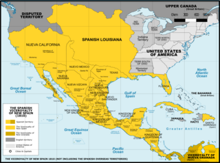
Español: Mapa del Virreinato de Nueva España en 1800. Sin incluir los territorios de ultramar en el Oceano Pacífico.
English: Map of the Viceroyalty of New Spain in 1800. Not including the viceroyalty's overseas territories in the Pacific Ocean.
Territorial organization of the Viceroyalty of New Spain (1535-1786)
Territorial organization of the Viceroyalty of New Spain (1786-1821)
|
||
| Datum | |||
| Källa |
A map created using information from the United States Geological Survey, an agency of the United States Department of Interior 1800, 1810, 1820 and from the Secretary of the Public Education of Mexico (Secretaría de Educación Pública de México) with 500 años de documentos COMMENT on 1 April 2015: The map above is still captioned "1810," instead of 1800. This is unfortunate and confusing, because in 1803 Spanish Louisiana was tranferred (to France and then) to the United States, so it makes the map appear to contain a serious error. ‘’’COMMENT on 13 August 2023: Date on the map above has still not been corrected to the actual year it represents, 1800. This leads to several inaccuracies, including for example misrepresentation of the size of the United States. In 1803 Ohio became a state, so it was no longer a territory by 1810. Such things were quickly changing in the 1800s, and the date on this map should be corrected.’’’ |
||
| Skapare | Giggette | ||
| Andra versioner |
|

.png)
.png)
.png)
.png#Disputed)
| Kameraposition | | Se denna och andra närliggande bilder på: OpenStreetMap |
|---|
.png¶ms=019.409500_N_-099.130700_E_globe:Earth_type:camera_type:satellite_region:MX_heading:0.00&language=sv)
Licensiering
- Du är fri:
- att dela – att kopiera, distribuera och sända verket
- att remixa – att skapa bearbetningar
- På följande villkor:
- erkännande – Du måste ge lämpligt erkännande, ange en länk till licensen och indikera om ändringar har gjorts. Du får göra det på ett lämpligt sätt, men inte på ett sätt som antyder att licensgivaren stödjer dig eller din användning.
- dela lika – Om du remixar, transformerar eller bygger vidare på materialet måste du distribuera dina bidrag under samma eller en kompatibel licens som originalet.

|
Tillstånd ges att kopiera, distribuera och/eller modifiera detta dokument under villkoren i GNU Free Documentation License, Version 1.2 eller senare version publicerad av Free Software Foundation, utan oföränderliga avsnitt, framsidestexter eller baksidestexter. En kopia av licensen ingår i avsnittet GNU Free Documentation License. |
Filhistorik
Klicka på ett datum/klockslag för att se filen som den såg ut då.
| Datum/Tid | Miniatyrbild | Dimensioner | Användare | Kommentar | |
|---|---|---|---|---|---|
| nuvarande | 21 november 2016 kl. 04.42 | | 1 600 × 1 192 (645 kbyte) | Giggette | Clearest |
| 1 juni 2014 kl. 22.14 |  | 1 600 × 1 192 (635 kbyte) | Giggette | Details | |
| 13 maj 2014 kl. 22.39 |  | 1 600 × 1 192 (634 kbyte) | Giggette | Details | |
| 13 maj 2014 kl. 22.34 |  | 1 450 × 1 080 (557 kbyte) | Giggette | Improving the design, adding elements | |
| 12 maj 2014 kl. 01.39 |  | 1 501 × 1 117 (549 kbyte) | Giggette | Adding details, lakes, cities, information | |
| 12 maj 2014 kl. 00.41 |  | 1 501 × 1 116 (538 kbyte) | Giggette | Adding missed provinces and clarifying information | |
| 6 maj 2014 kl. 19.54 |  | 1 501 × 1 116 (517 kbyte) | Giggette | Details | |
| 5 maj 2014 kl. 00.38 |  | 1 302 × 971 (450 kbyte) | Giggette | Details | |
| 6 juni 2013 kl. 19.33 |  | 1 450 × 1 084 (500 kbyte) | Giggette | mistake | |
| 6 juni 2013 kl. 19.30 |  | 1 450 × 1 084 (490 kbyte) | Giggette | {{Information |Description ={{en|1=x}} |Source ={{own}} |Author =Giggette |Date = |Permission = |other_versions = }} |
Filanvändning
Inga sidor använder den här filen.
Global filanvändning
Följande andra wikier använder denna fil:
- Användande på cs.wikipedia.org
- Användande på en.wikipedia.org
- Användande på fr.wikipedia.org
- Användande på gl.wikipedia.org
.png)