Montechiarugolo
Utseende
| Montechiarugolo | |
| Kommun | |
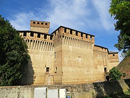
Castello di Montechiarugolo
| |
| Officiellt namn: Comune di Montechiarugolo | |
| Land | |
|---|---|
| Region | Emilia-Romagna |
| Provins | Parma |
| Höjdläge | 128 m ö.h. |
| Koordinater | 44°41′36″N 10°25′20″Ö / 44.69326°N 10.42219°Ö |
| Yta | 48,20 km²[1] |
| Folkmängd | 11 104 (2018)[2] |
| Befolkningstäthet | 230 invånare/km² |
| Tidszon | CET (UTC+1) |
| - sommartid | CEST (UTC+2) |
| Postnummer | 43022 |
| Riktnummer | (+39) 0521 |
| ISTAT-kod | 034023 |
| Geonames | 6538425 |
|
Montechiarugolos läge i Italien
| |
|
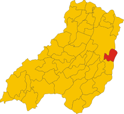
Montechiarugolos läge i Parma
| |
| Webbplats: Montechiarugolo | |
Montechiarugolo är en ort och kommun i provinsen Parma i regionen Emilia-Romagna i Italien. Kommunen hade 11 104 invånare (2018).[2]
Referenser[redigera | redigera wikitext]
- ^ ”Territorial features, Total area (Engelska)”. Istituto Nazionale di Statistica. 2019. http://dati.istat.it/. Läst 30 oktober 2019.
- ^ [a b] ”Statistiche demografiche ISTAT”. demo.istat.it. 2018. Arkiverad från originalet den 14 januari 2018. https://web.archive.org/web/20180114115045/http://demo.istat.it/bilmens2018gen/index.html. Läst 30 oktober 2019.
| ||||||||
|


