Surrey
Utseende
| Surrey | |||
| Ceremoniellt och administrativt grevskap | |||
|
|||
| Land | |||
|---|---|---|---|
| Riksdel | England | ||
| Region | Sydöstra England | ||
| Ingående distrikt | Spelthorne, Runnymede, Surrey Heath, Woking, Elmbridge, Guildford, Waverley, Mole Valley, Epsom and Ewell, Reigate and Banstead, Tandridge | ||
| Administrativ huvudort |
Reigate | ||
| Yta | 1 663 km²[1] | ||
| Folkmängd | 1 214 540 (2022)[2] | ||
| Befolkningstäthet | 730 invånare/km² | ||
| Tidszon | GMT (UTC+0) | ||
| - sommartid | BST (UTC+1) | ||
| GSS-kod | E10000030 | ||
| Geonames | 2636512 11609020 | ||
Surrey är ett grevskap i sydöstra England med en yta på 1 663 km2 och med cirka 1,2 miljon invånare (2022). Största ort är Woking. Den norra delen av Surrey består av förorter till London.
Den administrativa huvudorten är sedan 2021 Reigate.
Administrativ indelning
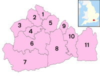
[redigera | redigera wikitext]Surrey är dels ett ceremoniellt grevskap (ceremonial county), dels ett administrativt grevskap som är en typ av sekundärkommun (non-metropolitan county). Det administrativa grevskapet är indelat i elva distrikt (non-metropolitan districts), som är en typ av primärkommun.
| Nr | Distrikt | Distrikten i Surrey |
|---|---|---|
| 1 | Spelthorne | 
|
| 2 | Runnymede | |
| 3 | Surrey Heath | |
| 4 | Woking | |
| 5 | Elmbridge | |
| 6 | Guildford | |
| 7 | Waverley | |
| 8 | Mole Valley | |
| 9 | Epsom and Ewell | |
| 10 | Reigate and Banstead | |
| 11 | Tandridge |
Källor
[redigera | redigera wikitext]- ^ ”Estimates of the population for the UK, England, Wales, Scotland, and Northern Ireland (Mid-2022)” (på engelska) (xls). Landyta, avrundad till hela km². Office for National Statistics. 26 mars 2024. https://www.ons.gov.uk/peoplepopulationandcommunity/populationandmigration/populationestimates/datasets/populationestimatesforukenglandandwalesscotlandandnorthernireland. Läst 25 juni 2024.
- ^ ”Estimates of the population for the UK, England, Wales, Scotland, and Northern Ireland (Mid-2022)” (på engelska) (xls). Office for National Statistics. 26 mars 2024. https://www.ons.gov.uk/peoplepopulationandcommunity/populationandmigration/populationestimates/datasets/populationestimatesforukenglandandwalesscotlandandnorthernireland. Läst 25 juni 2024.


