
Tidsresenärerna (säsong 11–15)
.jpg)
Tidsresenärerna (säsong 11–15) beskriver fem säsonger i den arkeologiska TV-serien Tidsresenärerna (Time Team). Säsongerna producerades 2003–2007 och sändes ursprungligen på Channel 4 2004–2008.
Säsonger och avsnitt[redigera | redigera wikitext]
Avsnittsnumreringen refererar till sändningsdatum och inkluderar även speciella avsnitt som sänds mellan den reguljära säsongens avsnitt. Specialavsnitten listas i Tidsresenärerna (övriga avsnitt).
Säsong 11 (2004)[redigera | redigera wikitext]
| Nummer | Nr/säsong | Originaltitel (översättning) | Plats | Koordinater | Originalvisning |
|---|---|---|---|---|---|
| 108 | 1 | "In Search of the Brigittine Abbey" (På jakt efter birgittinerklostret) |
Syon House, London | 2004-01-04 | |
| 109 | 2 | "A Roman Bath House and Edwardian Folly" (Romerskt badhus och edvardianskt lusthus) |
Whitestaunton Manor, Somerset | 2004-01-11 | |
| 110 | 3 | "The Crannog in the Loch" (Boplatsholmen i sjön) |
Loch Migdale, Scottish Highlands | 2004-01-18 | |
| 111 | 4 | "Saxon Burials on the Ridge" (Saxiska begravningar uppe på höjden) |
South Carlton, Lincolnshire | 2004-01-25 | |
| 112 | 5 | "The Roman Fort That Wasn't There" (Det gäckande romerska fortet) |
Syndale, Kent | 51°18′49″N 0°51′38″Ö / 51.313727°N 0.860548°Ö | 2004-02-01 |
| 113 | 6 | "An Iron-Age Trading Centre" (En järnålders handelsplats) |
Green Island, Dorset | 50°40′44″N 1°59′27″V / 50.67893°N 1.990799°V | 2004-02-08 |
| 114 | 7 | "A Medieval Blast Furnace" (En medeltida masugn) |
Oakamoor, Staffordshire | 52°59′21″N 1°56′23″V / 52.98913°N 1.939713°V | 2004-02-15 |
| 115 | 8 | "Rescuing a Mesolithic Foreshore" (Hur man räddar en mesolitisk strandremsa) |
Goldcliff, Newport | 51°31′57″N 2°54′14″V / 51.532536°N 2.903950°V | 2004-02-22 |
| 116 | 9 | "Fertile Soils, Rich Archaeology" (Bördiga jordar, rik arkeologi) |
Wittenham Clumps, Oxfordshire | 51°37′40″N 1°10′50″V / 51.627914°N 1.180515°V | 2004-02-29 |
| 117 | 10 | "King Cnut's Manor" (Knut den Stores herrgård) |
Nassington, Northamptonshire | 52°33′10″N 0°26′01″V / 52.552655°N 0.433747°V | 2004-03-07 |
| 118 | 11 | "Back-Garden Archaeology Revisiting a Roman villa" (Bakgårdsarkeologi under återbesöket vid en romerska villan) |
Ipswich, Suffolk | 52°04′35″N 1°07′56″Ö / 52.076522°N 1.132127°Ö | 2004-03-14 |
| 119 | 12 | "The Lost City of Roxburgh" (Den försvunna staden Roxburgh) |
Roxburgh, sydöstra Skottland | 55°35′51″N 2°26′54″V / 55.597499°N 2.448431°V | 2004-03-21 |
| 121 | 13 | "Brimming with Remains" (Upp till brädden med kvarlevor) |
Cranborne Chase, Dorset | 50°55′43″N 2°02′21″V / 50.928594°N 2.039061°V | 2004-03-28 |

Säsong 12 (2005)[redigera | redigera wikitext]
| Nummer | Nr/säsong | Originaltitel (översättning) | Plats | Koordinater | Originalvisning |
|---|---|---|---|---|---|
| 125 | 1 | "The Manor That's Back to Front" (Den bakvända herrgården) |
Chenies Manor House, Buckinghamshire[1] | 51°40′29″N 0°31′59″V / 51.674775°N 0.533114°V | 2005-01-02 |
| 126 | 2 | "The Monastery and the Mansion" (Klostret och herrgården) |
Nether Poppleton, Yorkshire | 53°59′18″N 1°08′56″V / 53.988279°N 1.148894°V | 2005-01-09 |
| 127 | 3 | "The Bombers in the Marsh" (Bombplanen i träsket) |
Warton, Lancashire | 53°44′07″N 2°56′07″V / 53.735285°N 2.935246°V | 2005-01-16 |
| 128 | 4 | "Fighting on the Frontier" (Kamp vid gränsen) |
Drumlanrig, Dumfries and Galloway | 55°16′17″N 3°48′27″V / 55.271321°N 3.807620°V | 2005-01-23 |
| 129 | 5 | "A Neolithic Cathedral?" (En neolitisk katedral?) |
Northborough, Peterborough | 52°39′43″N 0°17′31″V / 52.662008°N 0.291830°V | 2005-01-30 |
| 130 | 6 | "In Search of Henry V's Flagship, Grace Dieu" (På jakt efter Henrik V:s flaggskepp Grace Dieu) |
Bursledon, Hampshire | 50°53′43″N 1°17′15″V / 50.895397°N 1.287374°V | 2005-02-06 |
| 131 | 7 | "Going Upmarket with the Romans" (Romersk lyx) |
Standish, Gloucestershire | 51°46′41″N 2°17′27″V / 51.778168°N 2.290930°V | 2005-02-13 |
| 132 | 8 | "Picts and Hermits: Cave Dwellers of Fife" (Pikter och eremiter: Fifes grottmänniskor) |
Wemyss, Fife | 56°09′44″N 3°03′28″V / 56.162351°N 3.057839°V | 2005-02-20 |
| 133 | 9 | "Lost Centuries of St Osyth" (S:t Osyths glömda sekler) |
St Osyth, Essex | 51°47′56″N 1°03′47″Ö / 51.798826°N 1.063060°Ö | 2005-02-27 |
| 134 | 10 | "The Puzzle of Picket's Farm" (Pusslet vid Pickets gård) |
South Perrott, Dorset | 50°50′42″N 2°45′10″V / 50.844866°N 2.752691°V | 2005-03-06 |
| 135 | 11 | "Norman Neighbours" (Normandiska grannar) |
Skipsea, Humberside | 53°58′03″N 0°12′49″V / 53.967614°N 0.213551°V | 2005-03-13 |
| 136 | 12 | "Hunting the Romans in South Shields - Tower Blocks and Togas" (På jakt efter romare i South Shields – tornblock och togor) |
South Shields, Tyne and Wear | 55°00′02″N 1°25′58″V / 55.000462°N 1.432911°V | 2005-03-20 |
| 137 | 13 | "Animal Farm" (Djurfarmen) |
Hanslope, Milton Keynes | 52°07′34″N 0°52′25″V / 52.126082°N 0.873735°V | 2005-03-27 |

Säsong 13 (2006)[redigera | redigera wikitext]
| Nummer | Nr/säsong | Originaltitel (översättning) | Plats | Koordinater | Originalvisning |
|---|---|---|---|---|---|
| 143 | 1 | "The Bodies in the Shed – Glendon's Lost Graveyard" (Kropparna i skjulet – Glendons försvunna begravningsplats) |
Glendon, Northamptonshire | 52°25′26″N 0°45′28″V / 52.423777°N 0.757779°V | 2006-01-22 |
| 144 | 2 | "Villas out of Molehills" (Villor i mullvadshögarna) |
Withington, Gloucestershire | 51°49′59″N 1°57′09″V / 51.832918°N 1.952569°V | 2006-01-29 |
| 145 | 3 | "Rubble at the Mill" (Bruk i ruiner) |
Manchester | 53°29′14″N 2°14′11″V / 53.487311°N 2.236522°V | 2006-02-05 |
| 146 | 4 | "The First Tudor Palace?" (Det första Tudorpalatset?) |
Esher, Surrey | 51°22′25″N 0°22′37″V / 51.373740°N 0.376815°V | 2006-02-12 |
| 147 | 5 | "The Boat on the Rhine – A Roman Boat in Utrecht" (Båten på Rhen – En romersk båt i Utrecht) |
Utrecht, Nederländerna | 52°04′49″N 5°01′23″Ö / 52.080317°N 5.023004°Ö | 2006-02-19 |
| 148 | 6 | "Court of the Kentish King" (Vid den kentiske kungens hov) |
Eastry, Kent | 51°15′22″N 1°18′46″Ö / 51.256012°N 1.312794°Ö | 2006-02-26 |
| 149 | 7 | "The Monks' Manor" (Munkarnas herrgård) |
Brimham, Harrogate, Yorkshire | 54°03′46″N 1°39′46″V / 54.062747°N 1.662743°V | 2006-03-05 |
| 150 | 8 | "Castle in the Round" (Ett rundslott) |
Queenborough, Kent | 51°24′58″N 0°44′55″Ö / 51.416134°N 0.748727°Ö | 2006-03-12 |
| 151 | 9 | "Sussex Ups and Downs" (Sussex backe upp och backe ned) |
Blackpatch, Sussex | 50°52′30″N 0°26′36″V / 50.874978°N 0.443323°V | 2006-03-19 |
| 152 | 10 | "Birthplace of the Confessor" (Bekännarens födelseort) |
Islip, Oxfordshire | 51°49′30″N 1°13′58″V / 51.825050°N 1.232742°V | 2006-03-26 |
| 153 | 11 | "Early Bath" (Tidiga Bath) |
Ffrith, Flintshire | 53°05′25″N 3°04′11″V / 53.090283°N 3.069603°V | 2006-04-02 |
| 154 | 12 | "The Taxman's Tavern – A Roman Mansio" (Skattmasens pub – En romersk herrgård) |
Alfoldean, Horsham, Sussex | 51°05′07″N 0°24′17″V / 51.0852°N 0.4046°V | 2006-04-09 |
| 155 | 13 | "Scotch Broch" | Applecross, nära Skye, Skotska högländerna | 55°50′06″N 6°10′16″V / 55.834867°N 6.171225°V | 2006-04-16 |
Säsong 14 (2007)[redigera | redigera wikitext]
| Nummer | Nr/säsong | Originaltitel (översättning) | Plats | Koordinater | Originalvisning |
|---|---|---|---|---|---|
| 158 | 1 | "Finds on the Fairway" (Fynd på golfbanan) |
Isle of Man | 54°08′26″N 4°33′08″V / 54.140615°N 4.552331°V | 2007-01-14 |
| 159 | 2 | "There's No Place Like Rome" (Rom ljuva Rom) |
Blacklands, nära Frome, Somerset | 51°17′07″N 2°20′11″V / 51.285410°N 2.336253°V | 2007-01-21 |
| 160 | 3 | "School Diggers Medieval" (xxx) | Hooke Court, Dorset | 50°48′03″N 2°39′59″V / 50.800806°N 2.666475°V | 2007-01-28 |
| 161 | 4 | "The Druids' Last Stand" (Druidernas sista strid) |
Amlwch, Anglesey | 53°24′20″N 4°23′43″V / 53.405465°N 4.395224°V | 2007-02-04 |
| 162 | 5 | "Sharpe's Redoubt" (xxx) | Sandgate, Kent | 51°04′34″N 1°07′48″Ö / 51.076135°N 1.130013°Ö | 2007-02-11 |
| 163 | 6 | "A Port and Stilton" (Portvin och lite stilton) |
Stilton, Cambridgeshire | 52°29′38″N 0°16′47″V / 52.493863°N 0.279640°V | 2007-02-18 |
| 164 | 7 | "A Tale of Two Villages" (Två byar) |
Wicken, Northamptonshire | 52°02′53″N 0°54′54″V / 52.048170°N 0.914954°V 52°02′48″N 0°55′11″V / 52.046576°N 0.919587°V |
2007-02-25 |
| 166 | 8 | "No Stone Unturned" (Ingen sten lämnas orörd) |
Warburton, Greater Manchester | 53°23′48″N 2°26′19″V / 53.396554°N 2.438536°V | 2007-03-04 |
| 167 | 9 | "The Domesday Mill" (Domedagsbruket/-kvarnen) |
Dotton, Devon | 50°41′22″N 3°17′42″V / 50.689403°N 3.295137°V | 2007-03-11 |
| 168 | 10 | "The Cheyne Gang" (Cheyne-ligan) |
Chesham Bois, Buckinghamshire | 51°41′17″N 0°36′02″V / 51.688032°N 0.600434°V | 2007-03-18 |
| 169 | 11 | "Road to the Relics" (Vägen till relikerna) |
Godstone, Surrey | 51°14′24″N 0°04′00″V / 51.240100°N 0.0666°V | 2007-03-25 |
| 170 | 12 | "The Abbey Habit" (xxx) | Poulton, Cheshire | 53°07′33″N 2°53′18″V / 53.125909°N 2.888253°V | 2007-04-01 |
| 171 | 13 | "In the Shadow of the Tor" (xxx) | Bodmin Moor, Cornwall | 50°35′57″N 4°37′30″V / 50.599279°N 4.624914°V | 2007-04-08 |
-
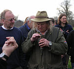 Bild från utgrävning från 2007. På bilden: John Gater, Victor Ambrus (skymd), Phil Harding och Matt Williams.
 -
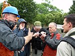 Tony Robinson med flera från Codnor Castle, 2007.
 -
 Tony Robinson och Phil Harding under utgrävning vid Codnor Castle, 2007.
 -
 Phil Harding i en Tidsresenärerna-grop i Suffolk, 2007.

.jpg)


Säsong 15 (2008)[redigera | redigera wikitext]
| Nummer | Nr/säsong | Originaltitel (översättning) | Plats | Koordinater | Originalvisning |
|---|---|---|---|---|---|
| 175 | 1 | "Gold in the Moat" (Guld i vallgraven) |
Codnor Castle, Derbyshire | 53°02′42″N 1°21′18″V / 53.045125°N 1.354947°V | 2008-01-06 |
| 176 | 2 | "Street of the Dead" (De dödas gata) |
Binchester, County Durham | 54°40′34″N 1°40′27″V / 54.676036°N 1.674253°V | 2008-01-13 |
| 178 | 3 | "Bodies in the Dunes" (Kroppar bland dynerna) |
Barra, Western Isles | 56°59′43″N 7°30′33″V / 56.995162°N 7.509125°V | 2008-01-20 |
| 179 | 4 | "The Naughty Nuns of Northampton" (De snuskiga nunnor i Northampton) |
Towcester, Northamptonshire | 52°09′02″N 0°57′10″V / 52.150658°N 0.952810°V | 2008-01-27 |
| 180 | 5 | "Mysteries of the Mosaic" (Mosaikmysteriet) |
Coberley, Gloucestershire | 51°50′07″N 2°02′59″V / 51.835399°N 2.049679°V | 2008-02-03 |
| 181 | 6 | "Blitzkrieg on Shooter's Hill" (Blixtkrig vid Shooter's Hill) |
South London | 51°28′14″N 0°04′16″Ö / 51.470522°N 0.071049°Ö 51°28′13″N 0°03′21″Ö / 51.470403°N 0.055911°Ö 51°28′25″N 0°04′16″Ö / 51.473722°N 0.071168°Ö |
2008-02-10 |
| 182 | 7 | "Keeping up with the Georgians" (xxx) | Hunstrete, Somerset | 51°21′24″N 2°30′35″V / 51.356569°N 2.509777°V | 2008-02-17 |
| 183 | 8 | "Saxons on the Edge" (Saxare uppe på kullen) |
Stonton Wyville, Leicestershire | 52°32′00″N 0°54′32″V / 52.533367°N 0.908772°V | 2008-02-24 |
| 185 | 9 | "Fort of the Earls" (Grevarnas fort) |
Dungannon, Northern Ireland | 54°30′N 6°46′V / 54.50°N 6.77°V | 2008-03-02 |
| 186 | 10 | "From Constantinople to Cornwall" (Från Konstantinopel till Cornwall) |
Padstow, North Cornwall | 50°33′25″N 4°57′05″V / 50.556811°N 4.951477°V | 2008-02-09 |
| 187 | 11 | "Five Thousand Tons of Stone" (Fem tusen ton sten) |
Hamsterley, County Durham | 54°41′33″N 1°50′25″V / 54.692457°N 1.840365°V | 2008-03-16 |
| 188 | 12 | "The Romans Recycle" (Romersk återanvändning) |
Wickenby, Lincolnshire | 53°20′10″N 0°21′31″V / 53.336229°N 0.358506°V | 2008-03-23 |
| 189 | 13 | "Hurting King Harold" (Att såra kung Harold) |
Portskewett, Monmouthshire | 51°35′21″N 2°43′31″V / 51.589040°N 2.725399°V | 2008-03-30 |
Se vidare[redigera | redigera wikitext]
Referenser[redigera | redigera wikitext]
- Den här artikeln är helt eller delvis baserad på material från engelskspråkiga Wikipedia, 31 juli 2013.
Noter[redigera | redigera wikitext]
- ^ Wessex Archaeology (2005-01): "Chenies Manor, Chenies, Buckinghamshire – An Archaeological Evaluation of a Tudor Manor House and an Assessment of the Results". Wessexarch.co.uk. Läst 10 augusti 2013. (engelska)
| ||||||||